Protected Natural Spaces (ENPs)
On July 29, 2005, the Consell de la Generalitat Valenciana declared Sierra Helada and its coastal surroundings a Natural Park with Decree 129/2005. This protection zone includes both terrestrial and marine habitats with especially relevant values, and with a high degree of conservation, partially including the municipalities of Benidorm, Alfaz del Pi and Altea.
Below is a summary of the attached documents.
The Sierra Helada is a mountainous alignment of tectonic origin that separates the bays of Benidorm and Altea. It is 6 kilometres long and has imposing cliffs that exceed 300 m in height. It is formed by calcareous and loamy materials from the lower Cretaceous and its organization took place in the middle-upper Miocene, between the Serravalian and the lower Tortonian.
It presents fossil dunes on slope areas and caves caused by water filtration, such as the Whale's Mouth, which has stalactites and stalagmites.
Mediana Island and Benidorm Island are extensions of the Sierra Helada so their composition is the same.
Throughout its entire surface, Sierra Helada exhibits great floristic biodiversity with several native species of interest that are in different states of protection. As for its fauna, the presence of seabirds is characteristic, due to its location, although some other species also appear such as birds of prey, non-marine nesting birds, bats and reptiles. The Island of Benidorm, for its part, highlights the presence of a seabird, the storm petrel.
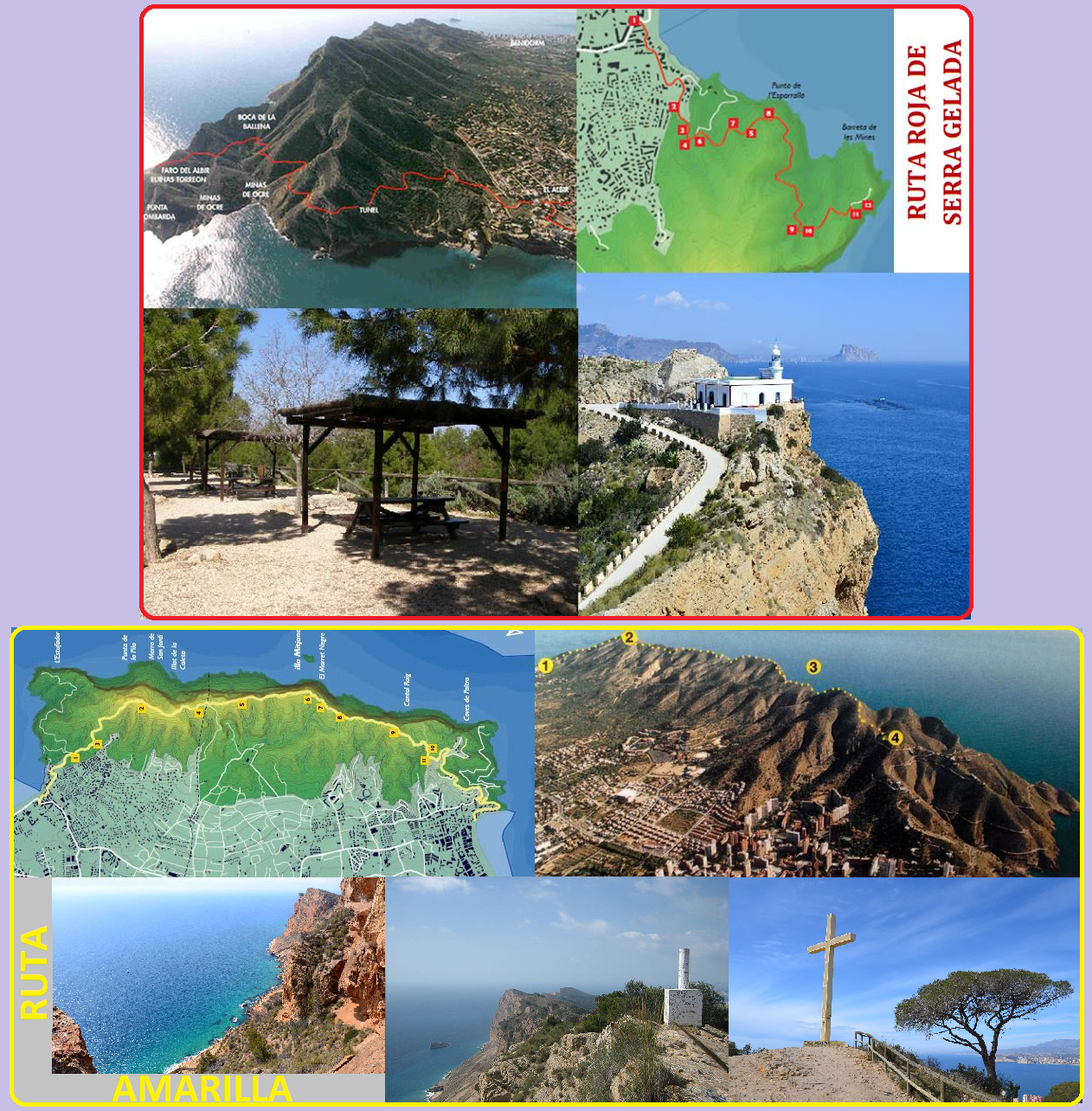
It has two routes for visitors, differentiated by the colours yellow and red and which can be accessed through the Generalitat Valenciana website.
(http://www.parquesnaturales.gva.es/es/web/pn-serra-gelada/rutas-y-senderos):
- Red route: also known as the Albir Lighthouse, it is a 5km round trip route with a duration of 1.5 – 2 hours and a maximum gradient of 112m, with a low difficulty that allows access to people with reduced mobility and bicycles. It is a paved road.
It starts from the Faro del Albir parking lot and you only need to follow the paved track to take the route in this colour, although it also has small deviations that teach other things and are named below. Along the way you pass through a recreational area, later you can go down to a cove, known as Doctor's Cove and later you can access two viewpoints until you reach a tunnel. Shortly after, to the left, there is a dirt diversion that leads to the old ocher mines and La Mina Cove and along another path located on the right side of the paved road, you can access a large cave known as Boca de la Ballena and visible at first glance from it. At the end of the path you reach the Albir lighthouse. The way back is the same in reverse. - Yellow route: It is a 6.5 km one-way route with a duration of 3.5 – 4 hours with a maximum gradient of 438m and presenting a medium–high difficulty.
It begins in the Albir recreational area and zigzags up some stone stairs until reaching the access road to the repeater and antennas, reaching the old “Alto del Gobernador” quarry and ending at the highest point of the mountain range. Continue along a paved area until you return to the path again where you can see the geodesic vertex. The path continues alternating slopes and slopes during which we can see the remains of a coastal surveillance house and a small cistern in the valley. All that remains is to follow the path until we reach a space with a large cross in its centre. From there, it is a paved road that ends at Levante Beach.
Benidorm Island
Visits are allowed in areas of public use but the presence of pets, fishing or overnight stays is not permitted. Vessels may not exceed 3 knots of speed when passing through its surroundings.
Mitjana Island
Access is not allowed, and boats passing through its vicinity may exceed 3 knots of speed.