This resource has been created to coincide with the 700th anniversary of the city's founding and will be presented on the occasion of World Tourism Day
Benidorm launches a print run of 1,500 copies of a new tourist map illustrated by artist Arly Jones

It captures the central landmark, marks 30 places of interest and includes street names such as the names of various streets, squares and even natural elements
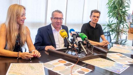
Benidorm City Council today presented a new tourist resource: a map illustrated by Alicante artist Arly Jones, the initial print run of which has seen 1,500 copies printed.
The Mayor, Toni Pérez; the Councillor for Historical and Cultural Heritage, Ana Pellicer; and the artist himself were responsible for unveiling this map, which is being published "to coincide with two very important celebrations for Benidorm: our 700th Anniversary and World Tourism Day."
Toni Pérez explained that "it is a graphic document" with "informative, artistic, and educational" value and that "it will not only allow us to visit some of Benidorm's must-see places, but will also provide a better understanding of the city and some of the circumstances" that explain the present of "a leading tourist destination" with a solid historical past.
This dual "historical-cultural and touristic" component, the mayor explained, is what led to "this illustrated map being produced in the year of our 700th anniversary, as part of the activities and initiatives deployed throughout 2025 to commemorate the founding of Benidorm. He also explains that it will be made available to the public on September 27, World Tourism Day, at the city's tourist offices."
As Toni Pérez explained, the map is limited to the central area of Benidorm, the area comprised primarily between Jaime I and Alfonso Puchades avenues and the three beaches—Levante, Mal Pas, and Poniente—extending this view to the island. Regarding this urban space, on the front of the document, "up to 30 points of interest have been identified, ranging from cultural and heritage resources to public spaces and services, unique features, and green areas." On the back, in turn, "we find unique features of the street map" with "historical value" that may be unknown "to new generations."
Specifically, the mayor elaborated, "we will tell the world who Tomás and Emilio Ortuño were and why they have a street in Benidorm; what two well-known squares, El Torrejó and La Creu, owe their names to what Levante and Poniente beaches were known as in the past; what object is submerged in the fountain in Elche Park; or the popular legend that accompanies the two most iconic rocks surrounding El Castell, 'El gos i la tortuga.'"
After emphasising that this is a "very special project," the mayor highlighted how "Arly Jones's ability and vision fit perfectly with this project to disseminate information about Benidorm," and applauded the joint work carried out by the artist and the Department of Historical and Cultural Heritage, whose relationship began in 2021 when the illustrator participated in a group exhibition.
Arly Jones, for his part, explained that "this map not only serves as an informative and guiding resource for tourists," but that "it was created with the intention of forming part of a graphic memory of the city of Benidorm, creating a beautiful object that can be framed and with which society and citizens can identify."
The artist thanked the City Council for "supporting this project," which also serves to convey a message of "pride" and "belonging" to Benidorm.
Both the Mayor and the Councillor for Historical and Cultural Heritage have suggested that, in addition to "reissuing" the document presented today, this initiative may be continued by extending the map to other areas of Benidorm.


